
Preliminary research and scheme design of deep underground in situ geo-information detection experiment for Geology in Time
2024-02-17 05:41HpingXiRuZhangZtianZhangYinshuangAiJianhuiDngYunChnYongZhouMingchuanLiLiqiangLiuMingzhongGaoZqianYangWiqiangLingHngGaoQijunHaoKunXiaoChniLou
礦業科學技術學報 2024年1期
Hping Xi ,Ru Zhang ,Ztian Zhang, *,Yinshuang Ai ,Jianhui Dng ,Yun Chn ,Yong Zhou,Mingchuan Li,Liqiang Liu,Mingzhong Gao,Zqian Yang,Wiqiang Ling,Hng Gao,Qijun Hao,Kun Xiao,Chni Lou
a State Key Laboratory of Intelligent Construction and Healthy Operation and Maintenance of Deep Underground Engineering,Sichuan University,Chengdu 610065,China
b College of Water Resource & Hydropower,Sichuan University,Chengdu 610065,China
c Guangdong Provincial Key Laboratory of Deep Earth Sciences and Geothermal Energy Exploitation and Utilization,Institute of Deep Earth Sciences and Green Energy,Shenzhen University,Shenzhen 518060,China
d Institute of Geology and Geophysics,Chinese Academy of Sciences,Beijing 100029,China
e Yalong River Hydropower Development Company Limited,Chengdu 610051,China
Keywords:Deep underground Geology in Time China Jinping Underground Laboratory In situ detection
ABSTRACT The deep earth,deep sea,and deep space are the main parts of the national‘‘three deep”strategy,which is in the forefront of the strategic deployment clearly defined in China’s 14th Five-Year Plan(2021–2025)and the Long-Range Objectives Through the Year 2035.It is important to reveal the evolutionary process and mechanism of deep tectonics to understand the earth’s past,present and future.The academic connotation of Geology in Time has been given for the first time,which refers to the multi-field evolution response process of geological bodies at different time and spatial scales caused by geological processes inside and outside the Earth.Based on the deep in situ detection space and the unique geological environment of China Jinping Underground Laboratory,the scientific issue of the correlation mechanism and law between deep internal time-varying and shallow geological response is given attention.Innovative research and frontier exploration on deep underground in situ geo-information detection experiments for Geology in Time are designed to be carried out,which will have the potential to explore the driving force of Geology in Time,reveal essential laws of deep earth science,and explore innovative technologies in deep underground engineering.
1.Introduction
Earth is the only known planet suitable for human survival.Exploring the fundamental scientific laws of the deep Earth and revealing the evolutionary process and mechanism of tectonics are of great importance for understanding the development Earth processes and promoting human survival and civilization development.The world’s most cutting-edge ‘‘125 Questions: Exploration and Discovery,” and ‘‘A Vision for NSF Earth Sciences 2020–2030:Earth in Time,” questions proposed by the National Science Foundation of the United States,such as How does Earth’s interior work?Are there earthquake precursors that can lead to useful predictions? What causes reversals in earth’s magnetic field? [1–3],highlight many unknowns within the earth,which make its study a challenging scientific frontier.
The environment and evolution of the deep earth have attracted significant attention from countries worldwide.The United States Geological Survey (USGS) proposed the Science Strategy for Core Science Systems (2013–2023) [4].This strategy places a strong emphasis on considering the critical zones of the earth as the primary focus.It aims to reshape research concepts within the field of geoscience,fostering interdisciplinary approaches.The goal is to address complex scientific and social challenges by building upon traditional foundations in geology and geography.The British Geological Survey (BGS) introduced a scientific strategy called Gateway to the Earth (2019–2023).This strategy outlines plans for geological research,including global geological information collection,earth energy exploration,and underground environmental monitoring.The BGS aims to establish a world-class repository of geological information to enhance our perception,understanding,and prediction of earth’s behavior.Globally,countries are actively implementing deep earth scientific exploration strategies to take the lead in this field.Deep earth exploration is one of the innovative fields of international future scientific and technological competition.
Facing the forefront of deep earth science,major developed countries have established underground laboratories,utilizing natural and artificially constructed systems of low background disturbance levels,and large environmental space conditions to explore the mysteries of the universe,the earth,and human survival.For example,the Laboratoire Souterrain à Bas-Bruit (LSBB) underground laboratory in France has become an observation station for earthquakes,hydrogeology,magnetic fields and radiation environments relying on its low levels of environmental background interference conditions [5].The LSBB integrates research in geology,geophysics,and hydrogeology [6].It engages in parametric modeling and 4D integration of geological models.Throughout the year,the facility conducts tests on seismic and geomagnetic signal coupling detection and research on the three-phase material exchange in the deep earth.These activities contribute first-hand information crucial for global geological activity monitoring and enhancing our understanding of the earth’s structure.The Spanish Laboratorio Subterráneo de Canfranc (LSC) in operation and the South American ANDES laboratory under construction,respectively,take the tectonic movement of the Pyrenees and the plate subduction of the Pacific Plate as important research topics to carry out long-term multiscale,multiphysics observations in the field.
In China’s 14th Five-Year Plan(2021–2025)and the Long-Range Objectives Through the Year 2035,the strategic deployment of strengthening original and leading scientific and technological breakthroughs in innovative fields such as deep land is targeted.Marching into earth’s depths is a strategic scientific and technical problem [7],which is the most innovative scientific issue and the most urgent practical problem.However,it is not easy to advance into the deep part of the earth.Based on traditional shallow and deep hole observation techniques and methods,it is difficult to quantitatively obtain comprehensive information about the internal sources of the deep earth,and there are some or even total data distortion.This phenomenon results in unclear correlation mechanisms between deep geological activities and shallow engineering geological responses.It also leads to incomplete exploration and development techniques for deep geological resources influenced by deep geological activities.Furthermore,there are unclear relationships between deep geological activities and shallow geomorphic evolution and source-sink systems,as well as climate change and other issues that directly impact human survival and development.
Hence,there is an urgent need to establish an in situ geological signal detection station,imbued with the academic essence of Geology in Time.This station will undertake Geo-information Detection Experiments (GeoDEX) in deep underground settings,allowing us to listen to the internal sounds (multi-field data) of the earth.The objective is to delve into the forefront of foundational deep earth science,unveiling the correlating geological mechanisms between time-varying internal geological information and time-varying shallow geological information in deep regions.This exploration aims to unravel the mysteries of the deep earth.
2.Current research status and trends of deep underground in situ detection
Researchers are still in the initial stage of exploring deep into the earth,and a series of problems still urgently need to be solved[7–9].In the 1970s,geophysics developed toward deep underground holes,deriving frontier disciplines such as deep-well geoscience,deep-well plate tectonics and geophysics [10].Regarding vertical depth,the deepest borehole created by human mining,the Kola ultradeep borehole,located in the Pechengsky District,Murmansk Oblast,Russia,reaches a depth of 12262 m but only touches 0.2%of the average earth depth[11].In continuous downward mining,the most prominent problem is the high pressure and high temperature that are far greater than at the shallow surface[12].Deep geological evolution is still unclear,making exploration more difficult.The fundamental reason is that there is a lack of reliable detection conditions for the deep geological environment.There are many problems and limitations in the detection methods,such as the inability to detect a single parameter to solve the multi-solution of the multi-field information,the interference caused by traditional shallow detection technology,and the low accuracy of mechanical or electromechanical detection instruments and equipment in the detection methods [13].
Deep hole detection can record weak changes in the surroundings that conventional ground stations cannot observe,and the detection signal-to-noise ratio significantly increases with depth(Fig.1).The SET refers to Seismic Emission Tomography,while VSP refers to Vertical Seismic Profile.Scientists from the United States,through the St.Andrews’observation deep hole experiment accurately measured in situ wave velocity stress changes before major geological events for the first time,confirming conclusions that were previously only present in the laboratory[14].However,the small space occupied by deep boreholes limits the detection accuracy and range of scientific instruments,and the accuracy and comprehensiveness of the obtained deep internal information are still insufficient.
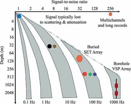
Fig.1.Detection of signal-to-noise ratio changes at different depths and frequencies [15].
The deep underground laboratory provides important experimental sites with a low background environment for conducting significant leading scientific research in particle physics,astrophysics,cosmology and other scientific fields.Additionally,it offers a suitable testing environment for conducting experimental research on the evolution of the earth’s structure,rock mechanics,ecology and other disciplines.The development process of international deep underground laboratories in the past few decades shows that deep underground laboratories can provide a comprehensive and significant scientific research platform for a country[16].Therefore,the construction and development of deep underground laboratories are of great scientific significance for basic scientific researches.
There are dozens of deep underground laboratories operating internationally,with interior volumes ranging from hundreds of cubic meters to tens of thousands of cubic meters and vertical rock cover thicknesses ranging from a few hundred meters to over two thousand meters.Representative underground laboratories include the China Jinping Underground Laboratory (CJPL),the Sanford Underground Research Facility (SURF) and the Waste Isolation Pilot Plant (WIPP) in the United States,the Sudbury Neutrino Observatory Laboratory(SNOLab)in Canada,the Kamioka Observatory in Japan,the Yangyang Underground Laboratory (Y2L) in South Korea,the INFN Gran Sasso National Laboratory (LNGS) in Italy,the Le Laboratoire Souterrain de Modane (LSM) in France,the Boulby Underground Laboratory in the UK,the previously mentioned LSC in Spain,and the Baksan Underground Scintillation Telescope (BUST) in Russia [17,18].Their depths are shown in Fig.2.Countries such as India,Chile,and Australia are also planning to build deep underground laboratories.In these laboratories,dark matter,double β decay,neutrino and other low background particle physics experiments have been carried out,including geotechnical mechanics,geosciences,gravitational wave experiments and further multi-disciplinary experimental research.Many deeply located underground laboratories have also established ultralow radioactive background measurement platforms,providing technical support for some low background experiments and other experimental measurements.
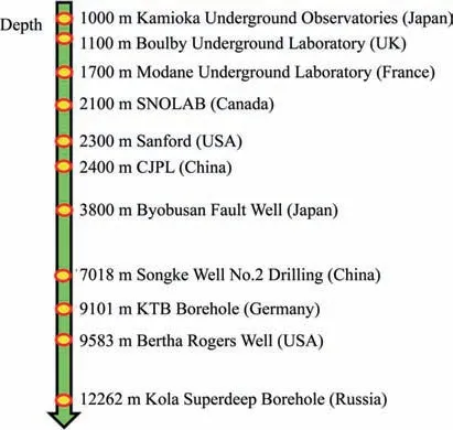
Fig.2.Depth of deep underground laboratories and scientific drilling in various countries.
3.Academic connotation and characteristics of Geology in Time
3.1. Academic connotation and scientific difficulties
At present,the existing research of Geology in Time focused on the earth mainly pertains to shallow surfaces.The research is disconnected from the earth’s internal processes without consideration for the impact of the internal evolution of the earth on the macroscopic mechanical response of geological bodies [5].Most relevant qualitative research lacks proper and effective in situ observational data to provide deep geological information.Simultaneously,due to limitations in observation techniques and experimental methods,quantitative acquisition of crucial information concerning the Geology in Time is challenging.Partial or complete distortion of information is possible,leading to an unclear understanding of the linkage mechanisms between deep geological activities and the response of surface engineering geology.The impact of deep geological activities on the exploration and development techniques of subsurface resources is still not wellestablished.
However,there is no unified understanding in the academic community of the scientific connotation of Geology in Time.In response to the essential attributes of deep geological environment evolution,the academic connotation of Geology in Time has been given for the first time,where the phrase refers to the accumulation of stress generated by regional tectonic movements under the geological processes inside and outside of the earth,causing different scales of geological bodies (from large crustal plates to small rock masses) to undergo steady-state/nonstationary evolution response processes at different time and spatial scales(Fig.3).Geology in Time spans the evolutionary process of different spatial geological bodies and environments across geological ages and human time scales.It provides sufficient geological time variation information and evidence that make it possible to solve major scientific problems related to human development (energy resources,spatial utilization,geological disasters).

Fig.3.Evolution of different geological bodies across time and spatial scales.
To explore the fundamental laws of deep earth science,it is imperative to focus on the internal processes within the earth’s deep interior.By integrating joint detection methods for both deep and surface geological phenomena,we aim to unveil the response mechanisms of Geology in Time across various temporal and spatial scales.Therefore,it will focus on the two front directions of time-varying law of geological information within the deep earth’s internal sources and time-varying mutual feedback mechanism of deep and shallow geological information.The core issue of Geology in Time is the correlation mechanism and law between deep endogenous variability and shallow geological response,based on the numerous problems that need to be overcome in existing research and the two cutting-edge directions mentioned above.The innovative research and cutting-edge exploration of Geology in Time are conducted under conditions of extremely low electromagnetic radiation and ultra-weak background noise.The research focuses on the in-situ detection of crucial information related to the geological time variation during its gestation.This involves the simultaneous and synchronized measurement of key deepseated internal sources,including gravity gradients,subtle deformations,and geomagnetic gradients,employing a same point synchronous and homologous approach.The precise separation and characterization of the propagation and evolution patterns of weak multi-field signals associated with geological time variation are carried out.The research aims to detect the evolving response processes of geological bodies at different scales under the influence of earth’s internal and external geological processes over various temporal and spatial scales.The goal is to achieve accurate detection of deep-seated internal multi-field time-variable signals and shallow surface time-variable response information,thereby revealing the driving sources and response mechanisms of Geology in Time.It is expected to achieve a breakthrough from 0 to 1 in the theory and technical system of deep underground in situ detection for time varying internal geo-information.
However,the core of understanding scientific issues related to deep geological variability and shallow response to geological formational processes is precisely detecting essential internal information in deep regions.The essential internal information of great scientific importance in Geology in Time is the gravitygradient time-varying information,long-period deformation time-varying information,and low-frequency vibration timevarying information.This information is extremely weak and difficult to capture via surface exploration,and there is an urgent need to monitor sound-signals generating from inside the earth in a deeply-placed location with low noise background levels.The underground laboratory environment has the advantages of a highly-stable detection environment,extremely low background interference level,and an extremely deep in situ detection space.The expansive space of the underground laboratory,with a larger observational area,facilitates the flexible deployment of large,high-precision instruments.This not only enriches the observation content but also enhances its reliability.This capability opens up the possibility of achieving a comprehensive joint detection of geological time-varying information in the deep earth.It enables the interpretation of geological time-varying issues,offering the potential for obtaining scientifically disruptive insights and understanding.
3.2. Basic characteristics of Geology in Time
The internal steady-state/nonstationary evolution process in the deep earth is accompanied by a large amount of coupling information of multiple physical fields,such as gravity,deformation,and geomagnetism,driving geological time-varying behavior between the deep earth and the surface.At the level of scientific theory,the existing fundamental theories of earth science lack accurate and effective support from deep in situ information and are limited to qualitative understanding of difficulties.At the methodological level,classical geological-body mechanics research focuses more on the shallow surface,which is seriously disconnected from the earth’s internal driving forces and spatiotemporal evolution effects.Hence,there is an immediate imperative to adopt a mechanical perspective and delve into the deep internal processes of the earth.The primary focus should be on addressing the pivotal scientific issues related to the correlation mechanism and law of deep internal time variation and shallow geological response.The exploration of Geology in Time necessitates a consideration of three fundamental characteristics across diverse space and time scales.These include the coupling of multi-field physical–mechanical representations,the correlation spanning mechanics across time and space scales,and the mutual feedback of the earth’s deep and surface mechanical responses.
3.2.1.Multi-fieldphysicalandmechanicalcharacterizationcoupling
With internal earth activities,the material in deep geological bodies will change due to earth’s micro-deformation,resulting in the gravity field of geological bodies gradually changing over time.The geological time-varying process contains rich deformation field,gravity field and electromagnetic field information.The coupling evolution process of various physical fields is complex.The gravity,electromagnetic and surface deformation data in time that can be observed are essentially bridges between the shallow geological bodies and the movement or deformation of the deep earth materials.It is vital in exploring plate tectonic movement and substance changes in the earth’s interior.A specific coupling movement relationship exists between the deformation of geological bodies and density varies.To characterize the coupling relationship of multiple physical fields (Fig.4),scientists have proposed many theories: solid tide theory [19],isostasy hypothesis [20],seismoelectric effect[21]and piezoelectric effect[22].However,the coupling of multifield physical and mechanical characterization still needs to be improved.To accurately interpret the coupling information of multiple physical fields,it is necessary to detect the same source and multi-field coupling information and the precise stripping analysis characterization.

Fig.4.Schematic diagram of Geology in Time multi-field physical–mechanical coupling.
3.2.2.Cross-correlationofspatiotemporalscalemechanics
The earth formed its most primitive crust 4 billion years ago,and the period that humans can monitor is minimal compared to the earth’s long geological development process.Geology in Time has a very large spatiotemporal span from the macro-to microscale and from long to transient[23–25].The long process of plate tectonic movement is similar to the mechanical experiment of rock failure.Currently,the mainstream theory of land and ocean origin focuses on discussing force sources.Earth’s fundamental driving force and mechanism differ at different stages,such as the mechanism causing lithospheric plate migration and the dynamic mechanical means of the deep earth.Exploring the spatiotemporal scale mechanical cross-correlation of the geological time-varying behavior from the perspective of mechanics (Fig.5) can reveal the long-term time-cross scale impact mechanism on the geological time-varying behavior,and has a critical driving role in solving the question of the macroscopic and microscopic mechanical essence of geological time-varying behavior under the coupling of multiple physical fields.
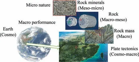
Fig.5.Schematic diagram of Geology in Time spatiotemporal mechanical correlation.
3.2.3.Deep-shallowmechanicalresponsereciprocity
From the perspective of human survival,the frequent occurrence of surface natural disasters,global warming,environmental degradation,and other issues is becoming increasingly prominent.However,the interaction effect and deep-shallow linkage between the deep evolution of the earth system and the mechanism of surface disasters are not clear [26],making these problems challenging to recognize and resolve.Regarding the leading causes of geological hazards,earthquakes and volcanic movements are usually defined as internal dynamic geological hazards.Regarding internal dynamic processes,plate movements and tectonic evolution are the fundamental causes of major geological disasters within the earth’s interior.External factors such as weathering,groundwater flow,climate change and human disturbance also play a crucial role in causing disasters.
With increasing research on major geological disasters with regional,periodic and group characteristics,an increasing number of studies have shown that it is difficult to reasonably explain the frequency,scale and distribution characteristics of such disasters from purely the internal or external dynamic effects.Causes are closely linked to the coupling between internal and external earth processes [27].Concerning the mutual feedback of deep and shallow geological and mechanical responses (Fig.6),interpreting the varied responses at different depths and elucidating the impact mechanism of internal time-varying effects on geological evolution and disaster occurrence can facilitate the establishment of a mechanical bridge.This bridge aims to connect the intersecting 3D mutual feedback of deep and surface geological time-varying behavior.It also contributes to the construction of a strategic research system focused on deep scientific laws and the mechanisms behind major geological disaster occurrences.

Fig.6.Evolution process of the deep shallow geological hazard chain[28].
4.Advantages and significance of conducting geo-information detection experiments for Geology in Time based on the CJPL
The CJPL is the world’s deepest underground laboratory in regards to the overburden depth,with a deep detection space of 2400 m,extremely low levels of background interference and a unique regional geological environment (geographical location and conditions).It provides a unique and advantageous detection platform for accurately obtaining first-hand geological timevarying information data in the long term,revealing the evolutionary processes and mechanisms of geological bodies and geological environments at different time and spatial scales.
First,the CJPL has a unique geological environment,located in the eastern foothills of the Qinghai Tibet Plateau and the transition zone of the first/second level terrain ladder.It is in front of the expansion of the southeastern edge of the Qinghai-Tibet Plateau.It is the ideal place for observing the far-field effects from continental collision and convergence between the Indian and Eurasian plates.It contains rich geological time-varying internal information,creating a unique trove of geological information for observing the edge of plate movement of the uplift and eastward expansion of the Qinghai Tibet Plateau.Scientific issues such as underground heat flow and mineralization and accumulation mechanisms under the influence of internal dynamics on earth have outlined significant scientific opportunities [29].
Second,the CJPL has a unique advantage in detecting deep in situ geological time-varying and extremely low background interference environments.Its Hall-D1 space has a volume of over 10000 m3,which can meet the joint detection needs of large-scale spatial precision instruments for same point synchronous and homologous geological time-varying information gathering.At the same time,the vast majority of the background levels of interference in the detection process will be effectively filtered out by the natural thick rock masses,effectively avoiding the instantaneous interference sources that cannot be eliminated in instrument measurement,which allows for the detectable range to be significantly expanded.Weak geo-information will be expected to be accurately captured,promoting a new understanding of scientific issues such as geotectonics,earthquake-causing mechanisms,and the rock-water–gas material conversion.
On the other hand,the GeoDEX will also become a vital component of the strategic concept of‘‘deep earth-surface”linkage exploration between the deep earth sciences and geological disasters,combined with surface array detection [27].Based on innovative research achievements in relevant fields both domestically and internationally,basic geological research will be strengthened based on the content of existing research.These works will produce more original achievements in the fields of geological research,earthquake prediction,and disaster prevention and mitigation on the Qinghai Tibet Plateau.At the same time,based on the multi-disciplinary advantages of the CJPL,deep underground in situ detection and geological time-varying research based on multi-messenger geology can be carried out,and the organic integration and innovative cooperation of geological science and experimental physical science can be practiced.The CJPL’s unique geological environment and exploration space provide a natural database of geological time-varying information,making it an excellent place to conduct deep underground in situ detection and geological time-varying research.
The 2400 m ultrathick mass of the overlying rock depth creates a deep in situ clean space with extremely low levels of background interference for performing CJPL geological time-varying detection.As the depth increases,the vast majority of background interference(such as vibration,electromagnetic radiation,and gravity disturbance) in the detection process will be filtered by the natural rock masses,effectively avoiding the instantaneous interference sources that cannot be eliminated in instrument measurement.The research team for this paper visited the CJPL multiple times to select six typical locations (Fig.7),including Hall-D1 (2400 m of depth),the auxiliary branch tunnel (approximately 2400 m of depth),the 21# cross passage (2400 m of depth),the 36# cross passage(1900 m of depth),the 6#cross passage(1500 m of depth),and the surface (0.2 m).Hall-D1 is an experimental hall within Hall-D of CJPL-II,and the auxiliary branch tunnel serves as an adit connecting CJPL-II to the drainage tunnel.The 6#,21#,and 36#cross passages function as connecting channels between Jinping traffic tunnels A and B.The vibration detection equipment included broadband seismometers and accelerometers.The magnetic field detection equipment included fluxgates,proton magnetometers,and optical pump magnetometers.Broadband seismometers encompass Meridian Compact PH,STS 2.5,and GL-CS60.The first two have a minimum frequency band of 120 s,while GL-CS60 operates at 60 s.STS 2.5 and GL-CS60 belong to the station type,and Meridian Compact PH is suitable for both station and shallow well installations.The accelerometer utilizes an integrated Nano-Titan.The flux gate device,LEMI424,is primarily employed for detecting relative magnetic field quantities.The proton magnetometer,GSM-90F,is designed for detecting absolute magnetic field quantities.Additionally,atomic clocks and data collectors for precise timing have been strategically placed near the equipment foundation.
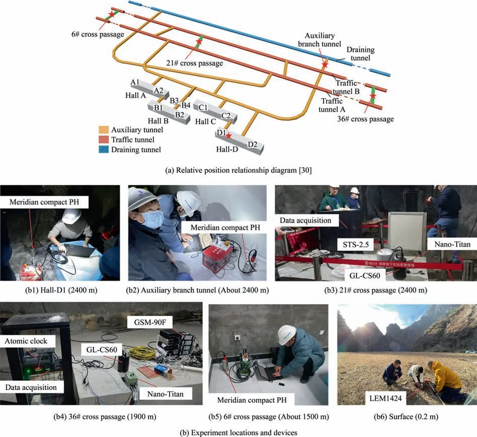
Fig.7.The CJPL confirmatory detection experiment locations.
In situ vibration and electromagnetic signal validation shortterm detection and background interference analysis evaluation were carried out(Fig.8).The analysis results of the vibration background interference detection indicate that the measured background interference signal level in a space buried at a depth of 2400 m is significantly lower than on the surface.The new high noise model (NHNM) curve represents the high noise model of the earth,while the new low noise model(NLNM)curve represents the low noise model of the earth.The A02 represents the vibration noise data curve measured in Hall-D1,the H06 represents the vibration noise data curve measured at the auxiliary branch tunnel,the T01 represents the vibration noise data curve measured at the surface,and the U01 represents the vibration noise data curve measured at the 6# cross passage.Two statistics were used to describe the characteristics of the power spectral density distribution,where p10 is the 10th percentile of the power spectral density,i.e.the energy distribution within the low-frequency range.Median is the median of power spectral density,which refers to the energy distribution that is not affected by extreme values.The low-frequency vibration background signal level in the 2400 m detection space is more than two orders of magnitude(100 times) lower than the low-frequency vibration background signal level at the surface.The background interference signal level of Hall-D1 is the lowest and superior to other areas of the large facility as well as the horizontal passage area.From the perspectives of time domain and frequency domain,it can be seen that signals buried at shallow depths will have more spike interference,and the background noise energy is relatively higher in frequency bands above 1 Hz.The analysis results of the geomagnetic background interference detection indicate the high-frequency electromagnetic background interference signal level in the 2400 m detection space is 1–3 orders of magnitude lower than the highfrequency electromagnetic background interference signal level on the surface.The differential characteristics of background noise levels at different depths of magnetic fields can also be obtained from the optical pump test data.Below 0.01 Hz,the energy level of background noise at a depth of 1700 m is closer to 2400 m,which is better than the background magnetic field environment at 1500 m.
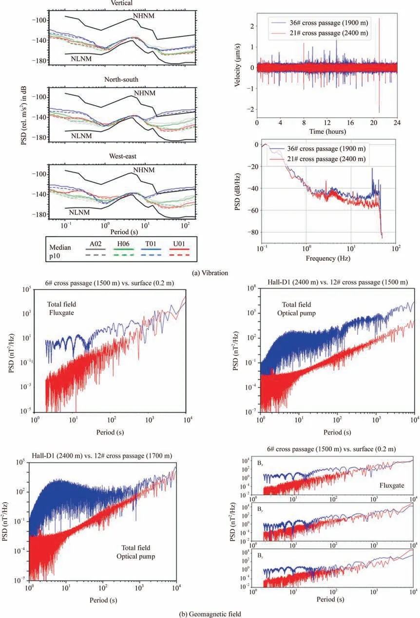
Fig.8.The CJPL short-term measurement of background noise power spectral density.
During the short-term exploration period,the large donor experimental hall was affected by interference from construction and electrical equipment throughout the entire period,but the detection results were still significantly better than the surface.The confirmatory short-term detection results of CJPL background signals indicate that the deep detection environment is considerably better than the surface,meaning that CJPL underground observation has an apparent characteristic of low environmental noise.By utilizing physical observation methods such as gravity,earthquake occurrences and electromagnetism levels,both domestic and foreign underground laboratories and deep well observation conclusions have confirmed the advantage of low levels of environmental background interference of underground observation locations,which have levels of environmental background interference significantly lower than that of surface-based observation points,and high-quality observation of weak geophysical signals is expected to be achieved [31–33].
In summary,relying on the advantageous observation conditions of the CJPL can effectively achieve deep in situ joint measurement of multi-field time-varying information with same point synchronous and homologous.Weak geological time-varying key signals will be extracted and interpreted.Conducting GeoDEX research and establishing the world’s deepest underground in situ detection station holds the potential to explore the driving force,spatiotemporal evolution process,and impact on humans associated with Geology in Time.This initiative can also test basic assumptions and theoretical models in earth science,leading to original,breakthrough,and disruptive discoveries in the genesis of geological time-varying phenomena.Additionally,it aims to unveil the essential laws of deep earth science and explore cutting-edge technologies in deep earth engineering.It has significant scientific importance and research value.
5.Conception of deep underground in situ detection experiments for time varying internal geo-information
Relying on the CJPL’s unique capability in environmental detection within large and deep underground spaces,the initiative addresses global,cutting-edge,and exploratory challenges in deep earth science.Following the layout of one central station and multi-auxiliary nodes,it involves constructing the central station for detecting internal geological time-varying information in deep underground and auxiliary stations for detecting regional geological time-varying information at different depths.This approach facilitates innovative research and cutting-edge exploration of GeoDEX under extremely low background interference conditions in the deep earth (Fig.9).CJPL is the central expansion tunnel of two 17.5 km traffic tunnels in Jinping Mountain,divided into CJPL-I and CJPL-II,with a burial depth of approximately 2400 m.The four experimental halls of CJPL-II are all arched tunnels that have undergone support,waterproofing,and radon suppression construction.The experimental hall is used for cutting-edge research such as dark matter,neutrinos,and deep earth science.GeoDEX is conducted in experimental Hall-D1.

Fig.9.The GeoDEX space layout diagram.
5.1.In situ detection of geological time-varying information from deep sources
The CJPL deep cavern space has the advantages of geological time-varying detection with extremely low levels of background interference and large space detection conditions,which can achieve the flexible deployment of large high-precision instruments and obtain richer,more reliable and accurate observation results than the surface.The central station for detecting internal deep underground geological time-varying information includes a control center,microscopic detection capabilities of Geology in Time,detection of internal geomagnetic information,detection of gravity gradient information and detection of weak deformation information.The goal is to explore the propagation,evolution and mutual feedback mechanisms of weak multi-field geological signals.Additionally,currently only preliminary conceptual design is involved.Specific details will be emphasized and elaborated in subsequent research.
5.1.1.Insitudetectionofgravitygradientinformation
The earth’s gravity field is one of the most fundamental physical fields in the near-earth space,and gravity is defined as the force that an object receives due to the earth’s attraction,which is the combined force of the earth’s gravity and centrifugal force on the object.More than 99.9% of the earth’s gravity field is controlled by the mass distribution of the earth’s interior.The spatial distribution,movement and change of matter under the action of the earth’s interior and exterior will cause weak changes in the earth’s gravity field in the time and space scales.The acceleration of gravity is influenced by many factors,such as solid tides,groundwater changes and underground material transport,and different geological time-varying activities will have different orders of magnitude effects on the acceleration of gravity[34–36].Improving the detection accuracy for each level of the gravity field information will provide substantial evidence for uncovering the evolutionary process of the earth’s structure.
The gravity gradient is the derivative of the gravity acceleration g=(gx,gy,gz)in space,which reflects the rate of change of the gravity field in thex,yandzdirections.It contains 6 independent components representing the underground geological body information in different directions.The gravity gradient anomaly refers to the difference between the actual and theoretical gravity gradients in a region due to the uneven mass distribution of the earth’s internal material.Due to the earth’s rotational and crustal movement,the gravity gradient values at the specified location constantly change,resulting in abnormal gravity gradient phenomena.Compared to the absolute value information of gravity,the gravity gradient tensor data contain higher frequency information,which can effectively constrain the multi-solution problem of traditional potential field data and more accurately and meticulously study the time-dependent laws of deep internal geology.
We constructed a method for the detection of gravity gradient information and configured gravity detection instruments such as quantum gravity gradients and superconducting relative gravimeters to carry out high-precision gravity gradient information measurements.The quantum gravity gradient meter is based on mirror magneto-optical trap (MOT) technology,which theoretically has no drift and is expected to achieve absolute gravity gradient measurement with long-term stability at the international first-class level of 1E (10-9s-2) [37].At the same time,the quantum gravity gradient also has the characteristics of high measurement accuracy and good long-term stability,which have suppression effects on the environmental vibration interference and a higher resolution for measuring earth density disturbances and can more finely and comprehensively reflect the spatial changes in the gravity potential.Among them,the iGrav superconducting relative gravimeter has a high level of sensitivity (0.3 μGal/Hz?),a high stability (drift rate less than 0.5 μGal/month) and a high precision(10-3μGal in the frequency domain and 0.05 μGal in the time domain) [38].It is recognized as one of the best instruments for detecting microgravity changes and is essential in measuring the earth’s gravity field over time.Based on the advantageous observation conditions of extremely low background interference in the CJPL-II geo-information detection environment at a depth of 2400 m,it is combined with quantum gravity gradiometers and superconducting gravimeters.A quantum gravity precision detection system is planned to be constructed.The accuracy of the gravity information observation has been improved to 10-7mGal,breaking through the accuracy range limit of mainstream gravimeters (10-3mGal).Geological time-varying weak gravity signals,such as the prompt elasto-gravity signals (PEGS) at the 10-6mGal level and the earth’s core super-rotation gravity signals at the 10-5mGal level,will be captured [39,40].
After various corrections and gravity network adjustments are made to the gravity observation data,the time-varying information of the regional gravity field is obtained through various differential methods,and the regional gravity field model is refined to provide precise gravity tidal corrections for the regional geodesy and geophysical observations.At the same time,based on the unique location of the CJPL at the eastern foot of the Qinghai-Tibet Plateau and in conjunction with gravity observation points in Wuhan,Hubei,Lijiang,Yunnan,and Lhasa,Tibet,which are in the same latitude area as the CJPL,the weak dynamic signals in the deep earth during the eastward expansion of the Qinghai-Tibet Plateau are studied.Relying on sharing high-precision global gravity observation data,we can research and monitor the weak global dynamic signals such as earth’s free nuclear nutation,earth’s free oscillation and core translational oscillation [41,42].
5.1.2.Insitudetectionofweakdeformationinformation
The movement and deformation patterns of deep geological bodies are a direct reflection of the internal geological time variation.They are affected by the internal and external effects of the tidal forces of the sun and the moon,as well as the activities of the earth’s core.Regional geological bodies often exhibit lowfrequency micro-deformation phenomena such as strain and inclined tides,slow slip and episodic tremors.The weak deformation of geological bodies is a type of geophysical information with rich connotations [43].
The key to detecting weak deformation information lies in the frequency band and accuracy,and frequency band extension and accuracy improvement are important ways to auscultate for deformation field information in deep geology.The sub-module of the weak deformation information detection center plans to carry out deep detection of geological body vibration deformation with a long period and a broad frequency domain.
The deep underground observation conditions of the CJPL have the characteristics of extremely low levels of background interference and constant temperature and pressure,which are conducive to overcoming the reflection,refraction and dissipation of microvibrations caused by the surface rock and the soil structure and preserving the fundamental vibration laws of the earth’s interior.It is important to carry out long-term monitoring and analysis of weak deformation of deep geological bodies and obtain regional vibration information to explore the regional tectonic activity,the low amplitude vibration of the earth’s background and the law of the earth’s natural pulsation.
We integrate world-class high-precision,high-sensitivity,broadband geophysical deformation field detection instruments,break through the conventional displacement and strain component fixed-point deformation mechanical detection framework and innovatively introduce a giant annular laser gyroscope,achieve high-precision coverage of the rotating component detection,build the world’s most advanced all-parameter optical weak deformation precision detection system,and achieve broadband (50 Hz,360 s)continuous detection of geological deformation information(displacement,strain,rotation signals) with a high accuracy (2–3 orders of magnitude higher than conventional borehole strain measurement) and a high sensitivity (noise sensitivity better than 10-11rad/s/Hz1/2),thereby capturing the evolutionary law of weak deep terrain deformation signals[44–46].Moreover,this detection system can extract multi-wave sources and full-vector features of geological deformation from a single point and track the source of deformation disturbance to realize the joint detection of the translational motion,the rotational movement and the local deformation in the same point synchronous and homologous.
5.1.3.Insitudetectionofgeomagneticgradientinformation
There is a natural magnetic field inside and surrounding the earth.The geomagnetic field is a vector field superimposed by multi-source magnetic fields.The time variation in the geomagnetic field results from internal factors (plate tectonics,geological body evolution) and external factors (cosmic rays,solar wind).Research has shown that the external field accounts for 1% of the earth’s magnetic field,while the internal field accounts for 99% of the earth’s magnetic field.Improving the geomagnetic information detection accuracy is essential in uncovering the evolution of the internal geological time-varying information on the earth.Additionally,it provides a crucial foundation for studying the internal structure of the earth and verifying the theoretical model of the earth’s core[47,48].The CJPL,covered by thick overlying rock,dramatically reduces the levels of background interference from external factors on the precise detection of the magnetic field,providing accurate magnetic field data evolution for exploring Geology in Time.
The geomagnetic gradient is the partial derivative of geomagnetic elements in 3D space,representing the rate of change in the geomagnetic field with spatial distance.The geomagnetic gradient is unaffected by factors such as daily variations in the standard geomagnetic field and can locate geomagnetic spatiotemporal anomalies with a high accuracy and resolution fidelity,achieving the traceability of deep geological anomaly events.To this end,observations of the internal geomagnetic field are carried out around the seven elements of the geomagnetic vector field and the geomagnetic gradient tensor.A 3D array is deployed in space to measure the geomagnetic gradient information,involving the magnetic flux gate,proton magnetometer,optical pump magnetometer and induction magnetometer in geomagnetic stations.The measurement of single-point,homologous,geomagnetic spatial gradient anomalies is achieved,forming a comparative observation with the geomagnetic network.At the same time,the construction of a superconducting geomagnetic whole tensor gradient detection system is expected to achieve precise detection of fT-level geomagnetic gradients,capturing timevarying instantaneous magnetic signals (pT-level) that cannot be detected by standard magnetometers,which measure at the nTlevel [49,50].To achieve high-precision and high spatiotemporal resolution observations of the earth’s basic and changing magnetic fields and to provide high-quality data support for geological disaster monitoring and prediction,earth science research,national defense construction,and high-quality socioeconomic development [51,52].
5.1.4.Microscopicdetectionofgeo-information
Gravity [53],electromagnetic [54],deformation [55] and other time-varying information [56] are inherent physical properties that do not disappear with a reduction in geological scale and are also the main manifestations of the geological time-varying evolution processes.The geological time-varying multi-field dynamic cascading effect is an essential direction in geophysical research,and its microscopic detection has always been one of the most important basic fields in the scientific community [57].However,it is not easy to regulate the generation and propagation of multiple physical fields at the geological scale,and it is even more challenging to extract key signals from a single field effectively.Therefore,a geological time-varying micro-detecting substation is constructed based on the high-precision macroscopic joint measurement of geological time-varying phenomena deep underground.Through precise control and detachment of key field sources,the micro-physical and mechanical processes and mechanisms [58,59] behind the macroscopic geological time-varying phenomena are actively detected,which is expected to reveal the micro-mechanical essence of extremely weak multi-field dynamic cascading effects and reconstruct the existing understanding of deep engineering problems.
As the detection scale decreases,the factors influencing the geological body structure with time-varying multifield mutual feedback will gradually decrease.However,the time-varying key signals will also be weaker,and the extremely weak fluctuation of the background detection field will enhance the impact,making it difficult to accurately detect anomalies at the microspatiotemporal scale.To this end,based on the deep underground environment of the CJPL,an internationally leading deep in situ low-magnetic detection experimental space for electromagnetic deformation field stability control will be constructed inside the central station for detecting the internal geological time-varying information in deep underground.Active compensation devices and passive shielding structures will effectively eliminate the influences of interference of the geomagnetic and magnetic fields.A foundation will be laid to achieve the micro-active regulation detection and information interpretation of the same point synchronous and homologous geological time-varying multi-field mutual feedback mechanism and to deeply reveal the mystery of the essence of geological time-varying micromechanics.
In the microscopic detection of geo-information,a geological time-varying micro-active detection experiment is conducted.This experiment aims to achieve extremely weak micro-scale space–time signal detection and explore the mechanical mechanisms behind the time-varying deformation field,gravity field,electromagnetic field,and the coupling of multiple fields over time.The goal is to establish a cross-scale correlation between geological time-varying anomalies and typical tectonic activities.The weak anomalous signals are of great scientific significance for understanding the time-varying micro-mechanism of geological forces,interpreting abnormalities induced by geological activities,exploring the geological history,achieving nonlinear multi-field geological-tracing time-varying detection,and revealing the micro-fuzzy critical identification mechanism of the geological time-varying domain.
5.2. In situ detection of regional geological background time-varying information
The geological bodies at various depths in Jinping Mountain,influenced by the time-varying effects of multiple internal fields in the deep earth,harbor abundant regional geological timevarying ‘‘deep earth-surface” feedback information.This includes details on physical mechanics and rock layer responses,making it an excellent experimental site for monitoring the ‘‘deep earthsurface”linkage and studying the regional geological background’s time-varying information.GeoDEX utilizes different depths,surface and peak areas of the 17.5 km traffic tunnel in Jinping Mountain as auxiliary stations (Fig.10) to carry out distributed geophysical and geomechanical information detection and to provide data support for the regular noise stripping of the internal geological time-varying information in the central station,establish a regional geological background time-varying multifield information auxiliary detection group,and to ensure the joint tracing and interpretation of geological time-varying deep and shallow surface time-varying information:(1)through the detection of different cross passages,the filtering of detection information in the central station is achieved,and the purification and noise reduction of internal geological time-varying information are achieved;and(2) obtain more time-varying response information of rock layers at different depths and achieve deep underground and surface mutual feedback linkage detection.
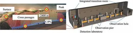
Fig.10.Schematic diagram of detection points for the time-varying information of the regional geological background.
Specifically,integrated transition rooms should be established at both ends of the cross passages at different depths,necessary experimental consumables,equipment data collectors,emergency power supplies and network equipment for various instruments should be placed,and appropriate emergency devices and kits should be prepared.Functioning as crucial transition spaces at both ends of a single cross passage,they will offer sound insulation and insulation functions for monitoring equipment.This ensures a relatively stable operating environment for detecting internal geological time-varying information,ultimately guaranteeing the authenticity and accuracy of the detected geological time-varying information.
The overall internal layout adopts a symmetrical arrangement on both sides,fully utilizing space while avoiding interference between equipment.A pedestrian path will be reserved in the middle along the length-direction for regular equipment debugging and maintenance.Array-type foundation piers and piles are to be constructed in each cross passage,and multiple types of multifrequency band coverage,and advanced gravity,magnetic,and electrical seismic detection systems will be jointly arranged.At the same time,an integrated monitoring system for the water and gas environment of the chamber will be established to accurately and synchronously monitor water temperature,water level,water quality,temperature,humidity,and pressure of each auxiliary station and detect changes in the background conditions through experiments.
Shapes of geological bodies with different densities within Jinping Mountain are imaged in 2D and 3D using shallowly-buried areas so the abnormal structure of the geological strata and the time-varying signal of the geological density can be accurately recognized.Based on high-sampling-rate,high-density,distributed optical fiber-sensing technology,long-distance high-density strain monitoring information is realized by laying optical fibers along the entire traffic tunnel.In summary,the time-varying information detection chain of the regional geological background is formed at the depth of Jinping Mountain,and the time-varying multifield auxiliary information detection of the regional geological background at different depths is studied in terms of gravity,electromagnetic,vibration,rock density,gas and groundwater.
In addition,control observation points should be established at the surface and appropriate mountaintop locations.Deployment of miniaturized instruments for the long-term monitoring of gravity,magnetic,electric and seismic multi-physics,as well as partial monitoring of the environment.The construction and use of equipment standards are the same as the array layout in the horizontal channel to research the time-varying multi-field information detection of the geological background in the same point surface relative to the deep earth.By comparing the monitoring information of deep observation points,precise stripping of regional regular geological time-varying signals is achieved,and the coupling law of regional geological time-varying information between deep earth surfaces is explored,ultimately serving the long-term stability of deep rock engineering projects such as in Jinping and the warning and mitigation of regional geological events.
6.Conclusions
In the innovative field of deep underground exploration and engineering science,which will be a focus of key international scientific and technological competition in the future,the CJPL’s advantages in the deep underground in situ exploration space and its unique geological environment will be relied on.Aiming at the two cutting-edge directions of time-varying law of geological information within the deep earth’s internal sources and timevarying mutual feedback mechanism of deep and shallow geological information,the focus is on exploring the steady-state/nonstationary evolution response process of geological bodies at different time-spatial scales under the influence of geological processes both inside and outside of the earth.The goal is to accomplish the same point synchronous and homologous deep underground in situ measurement of multi-field information,which holds significant scientific importance in geological timevarying processes.This includes parameters such as gravity gradient,weak deformation,geomagnetic gradient,as well as the collection and interpretation of key weak geological time-varying signals.The aim is to reveal the propagation,evolutionary rules,and mutual feedback mechanism of weak geological timevarying multi-field signals.
The GeoDEX research will provide sufficient geological timevarying information and evidence for studying the evolutionary processes of spatially different rock masses and geological environments across geological eras and human time scales.It is expected to explore the driving source,the Geology in Time spatiotemporal evolutionary process and its impact on humans,test the basic assumptions and theoretical models of earth science,and obtain original,breakthrough and disruptive discoveries in the geology process over time.Revealing the essential laws of deep earth science,exploring innovative technologies in deep earth engineering,and achieving a breakthrough from 0 to 1 in the innovative construction of deep underground in situ detection and geological time-varying theory and technology system have significant scientific importance and research value.
In China’s 14th Five-Year Plan(2021–2025)and the Long-Range Objectives Through the Year 2035 document,strengthening the strategic deployment of original and leading scientific and technological breakthroughs in innovative fields such as the deep earth environment is targeted.The development of deep underground engineering and the exploration of fundamental laws of deep earth science are related to the national-level implementation of deepearth strategies and innovative technological innovation.This article preliminarily verifies that the CJPL has the advantage of a detection environment with an extremely low level of background interference,which is conducive to improving the measurement accuracy of precision instruments and is expected to achieve adequate detection of key geological time-varying weak signals.Therefore,this study will ensure the joint tracing and the interpretation of the geological time-varying deep-and shallow-surface time-varying information,and serve the forward-looking exploration of deep geological scientific laws,and evaluate the safety and long-term stability of major deep surrounding rock geological engineering.This study will assist in innovative research and practical deep geological science and engineering development.
Acknowledgements
This work was supported by the National Natural Science Foundation of China (Nos.52125402 and 52174084) and the Natural Science Foundation of Sichuan Province of China (No.2022NSFSC0005).
- 礦業科學技術學報的其它文章
- Numerical and experimental investigation on hydraulic-electric rock fragmentation of heterogeneous granite
- Heat transfer and temperature evolution in underground mininginduced overburden fracture and ground fissures:Optimal time window of UAV infrared monitoring
- Classifying rockburst with confidence: A novel conformal prediction approach
- Drilling-based measuring method for the c-φ parameter of rock and its field application
- Pore-pressure and stress-coupled creep behavior in deep coal: Insights from real-time NMR analysis
- Experimental investigation of the inhibition of deep-sea mining sediment plumes by polyaluminum chloride